
New Zealand is renowed for its stunning diversity, from the majestic and dramatic fjords of Milford Sound, to the lush meadows of Middle-earth and the rugged coastline of Otago. There is something for every type of nature traveler. And there’s one craving that many people visiting to New Zealand come to fulfill: hiking through volcanic wastelands, with Taranaki & Tongariro national park being the most notable examples. And Tongariro National Park certainly offers the country’s most iconic hike: the Tongariro Alpine Crossing.
I’ve had the chance to complete the Tongariro Alpine Crossing twice. In this article, I’ll share some tips on how to prepare for this unforgettable hike, along with a glimpse into the legends that surround this volcanic park.
It’s a challenging day but a memorable one !
DATA OF THE TONGARIRO ALPINE CROSSING
- Distance : 20,2 km one way.
- When to hike : November to April – clear & not too much cloudy weather only.
- For who : moderate level but suitable for everyone
- How long : 6 to 8h depending on your level and the weather
- Elevation gain : + 800m / – 1100m
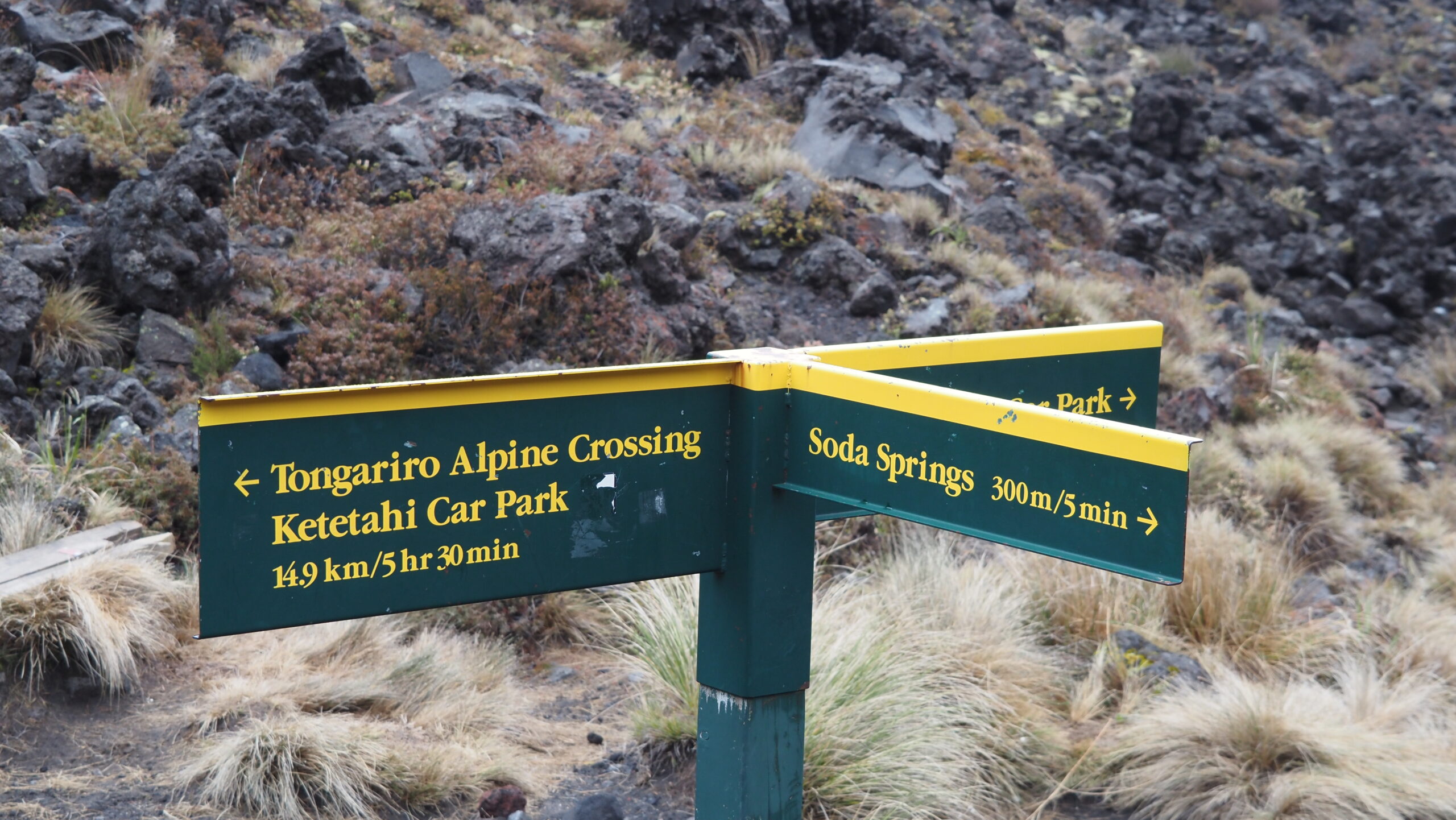
- Hilights : Mangatepōpō Hut – Soda Springs – Mont Tongariro – Red crater – Emerald Lakes – Blue Lakes – Ketetahi Hot springs (closed).
1. TONGARIRO, A SACRED PLACE FOR MAORI
In the beginning, according to legends, the national park was made up of 5 volcanoes: Taranaki, Tongariro, Ruapehu, Ngauruhoe and Pihanga (the only woman). Pihanga was attached to Tongariro, but in her absence, Taranaki tried to conquer her, causing Tongariro to erupt into a rage. A fierce battle ensued between the two mountains, with Tongariro emerging victorious. In defeat, Taranaki exiled himself to the west, digging the Whanganui River in his wake (the first natural entity in the world to have a legal personality, by the way). Today, from Mount Ruapehu, you can see the conical shape of Taranaki, more than 100 kilometers away.
Today, the Tongariro national park is a sacred place for the Maori community. In the 19th century, the chief of the tribe offered the land to the British crown to protect it from exploitation and destruction by new arrivals. Out of respect for their culture and for the preservation of the park, I recommend respecting all the sacred prohibitions (tapu) of the park: don’t climb Mount Ngauruhoe, don’t swim in the Blue Lakes and, of course, don’t litter (human, organic, plastic).
Tongariro National Park is also a must-see if you’re a fan of the Lord of the Rings universe. Mount Ngauruhoe, one of the volcanic peaks, lends its silhouette to Mount Doom, located in Mordor. It is because og the volcano’s fire that Sauron forges the Ring there, and it is thanks to its fire that it will be later destroyed by the two Hobbits.
2. HOW TO GET TO THE TONGARIRO ALPINE CROSSING
Firstly, you need to get closer to the Tongariro National Park.
- By bus from Auckland : Intercity buses depart daily (except Tuesday and Saturday) towards National Park, the closest location to the start of the Tongariro Alpine Crossing. You can also stop in Turangi (daily departures from Auckland) or Taupo, the largest nearby city (with multiple daily departures). Travel time: 4 to 6 hours. Price: starting from 40 NZD.
- By bus from Wellington : Intercity buses also run towards National Park, Turangi, and Taupo. Travel time: 6 to 7 hours. Price: starting from 30 NZD.
- By car : National Park village is a 4-hour drive from both Auckland (300 km) and Wellington (300 km).
- By plane : Air New Zealand and Jetstar offer direct flights to Taupo multiple times a day from Auckland and Wellington. Price : starting from 60 NZD.
Once you are close by the park, you will need to take a shuttle to get to the starting point of the hike. Parking at the trail beginning is limited to 4 hours, and since the hike does not finish where it starts, booking a shuttle is, in principle, mandatory. You have 3 options :
- Take a round-trip shuttle that picks you up near your accommodation and drops you off at the meeting point (around 60NZD/pers)
- Drive your car and park at the end point of the hike, then book a shuttle to take you to the starting point: Mangatepopo (around 50NZD/pers)
- If you are really low on budget, you can hike to the top and then return the same way to avoid paying. Alternatively, hitchhiking is quite easy as it’s a popular place.
3. ESSENTIALS TO PACK FOR HIKING IN TONGARIRO NATIONAL PARK
Local authorities and local shuttle companies don’t joke with safety precautions before beginning the hike. The weather can be extremely unpredictable: being at a high altitude, it can quickly turn rainy, very cold with fog reducing visibility to less than 100 meters, or be sunny. There’s often wind as well. Therefore, it is essential to prepare for:
- A windbreaker / Rain jacket
- Warm clothing: You’ll start the hike early in the morning, and it can be much colder than in Turangi or Taupo. It’s best to wear a lightweight base layer and 1-2 warm layers that you can remove throughout the day.
- Sun protection accessories : as well you can opt for a beanie or a hat and sunglasses as the sun can be extremely harsh (this is true everywhere in NZ, by the way). Don”t forget to apply sun protection !
- 2 liters of water: The hike lasts at least 6 hours and there’s no source of drinkable water during your walk.
- Food : Bring enough food for energy; small snacks may not be sufficient, as the ascent can be exhausting.
- Good hiking shoes : It’s easy to slip and injure yourself, especially when crossing the plateau as for every 3 steps you take forwards, you may slide back two. Therefore, make sure to wear sturdy closed-toe hiking shoes.
- Your phone and a spare battery in case of emergency: The emergency number in NZ is 111.
- Trekking poles: Not essential, but they can be very helpful.
4. BEST TIMES TO HIKE THE TONGARIRO ALPINE CROSSING
The hike is accessible year-round; however, it is not suitable for everyone at all times. In summer, from November to March, it is open to hikers of all levels. However, from the end April until late October, it is recommended only for experienced climbers, as the volcanoes become covered in a thick layer of snow, making the ascent dangerous or even fatal without a guide and specialized equipment.
It is also common for the hike to be closed during peak season, especially due to bad weather (heavy rain, too much fog) or strong winds. You can check directly with the shuttle company or check the Tongariro National Park Visitor centre for updates on the open or close status. It is extremely important to listen to their advice; if they say it’s not possible, don’t attempt it. Having hiked part of my great walk (Tongariro Northern walk) in windy conditions, I can assure you it was extremely exhausting and dangerous, and I was scared for my safety more than once.
TIPS : if the Tongariro Alpine Crossing is a must-do on your trip and you have some flexibility in your schedule, I recommend planning to stay in the area for 2-3 days in case you can’t hike due to the weather. If the weather does not permit the hike but you still want to explore the park, there are two alternative hikes that I recommend : Taranaki Falls hike (2h | 6km loop track) and going further with the Tama Lakes track (5–6 hr | 17 km return on same track)
4. IS THE TONGARIRO SUITABLE FOR EVERYONE ? IS IT AN EASY HIKE ?
There’s a debate about whether everyone can hike. In theory, yes. I encountered families with children over 12 who successfully completed the hike, as well as some older persons in great shape completing the 20 kilometers.
However, it’s crucial to know your limits. If you’ve never hiked before, prepare as best as you can, take your time, and make regular breaks. Generally, you start early, around 7 a.m., and in summer, the sun doesn’t set until after 8 p.m. So, you have plenty of time! Still, don’t push yourself to do something you feel you can’t finish, as there are other family-friendly alternatives.
TIPS : As a solo traveler, if you are intimidated to walk such a long distance, it’s easy to find people doing the same as you through various Facebook groups. Each day, many individuals tackle the hike on their own. Additionally, if you’re staying at a nearby hostel, they often organize tours, allowing you to join a group!
5. TONGARIRO ALPINE CROSSING TRAIL ITINERARY
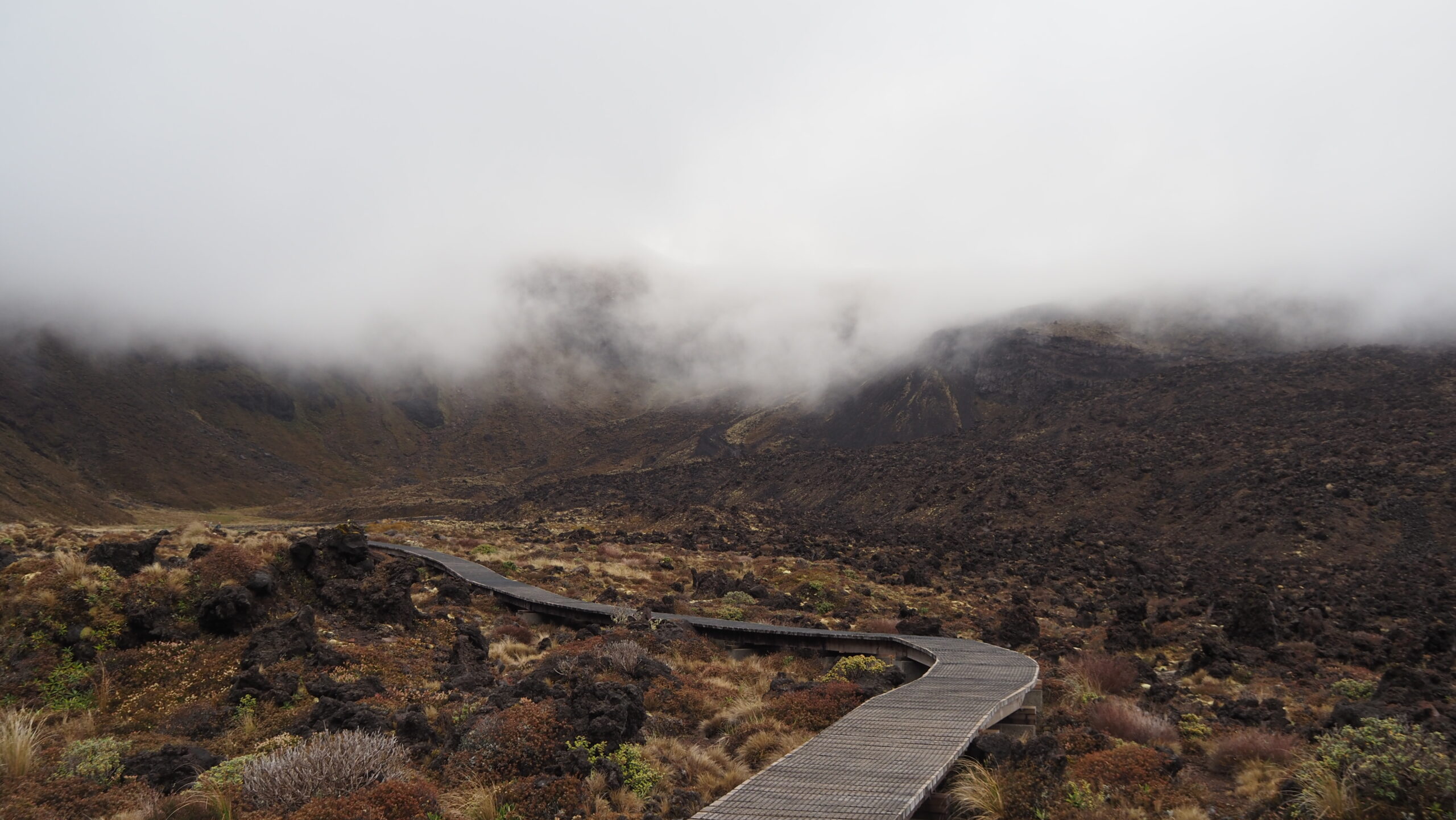
The shuttle option will drop you off at the Mangatepōpō Road end car park. From there, a sign will quickly inform you: Tongariro Alpine Crossing: 20,4 km. When we did it on a early morning of late November, the path was surrounded of a chilly gloomy mist that barely lifted from the surrounding volcanic mountains. The first hour gradually ascends, which is relatively easy. You’ll reach quickly Mangatepopo Hut, which serves a a marker for a first break. There’s also dry toilets located along the trail, stocked with toilet paper. Once you pass a series of waterfalls (Soda Springs) at 5 km from the starting point, you begin to climb even higher, and this is where you’ll need to draw on your determination.
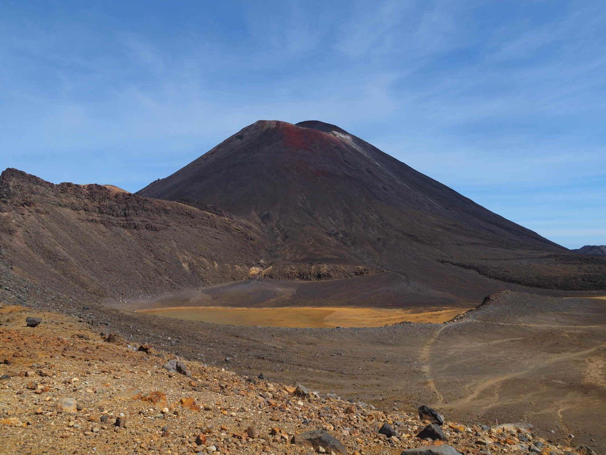
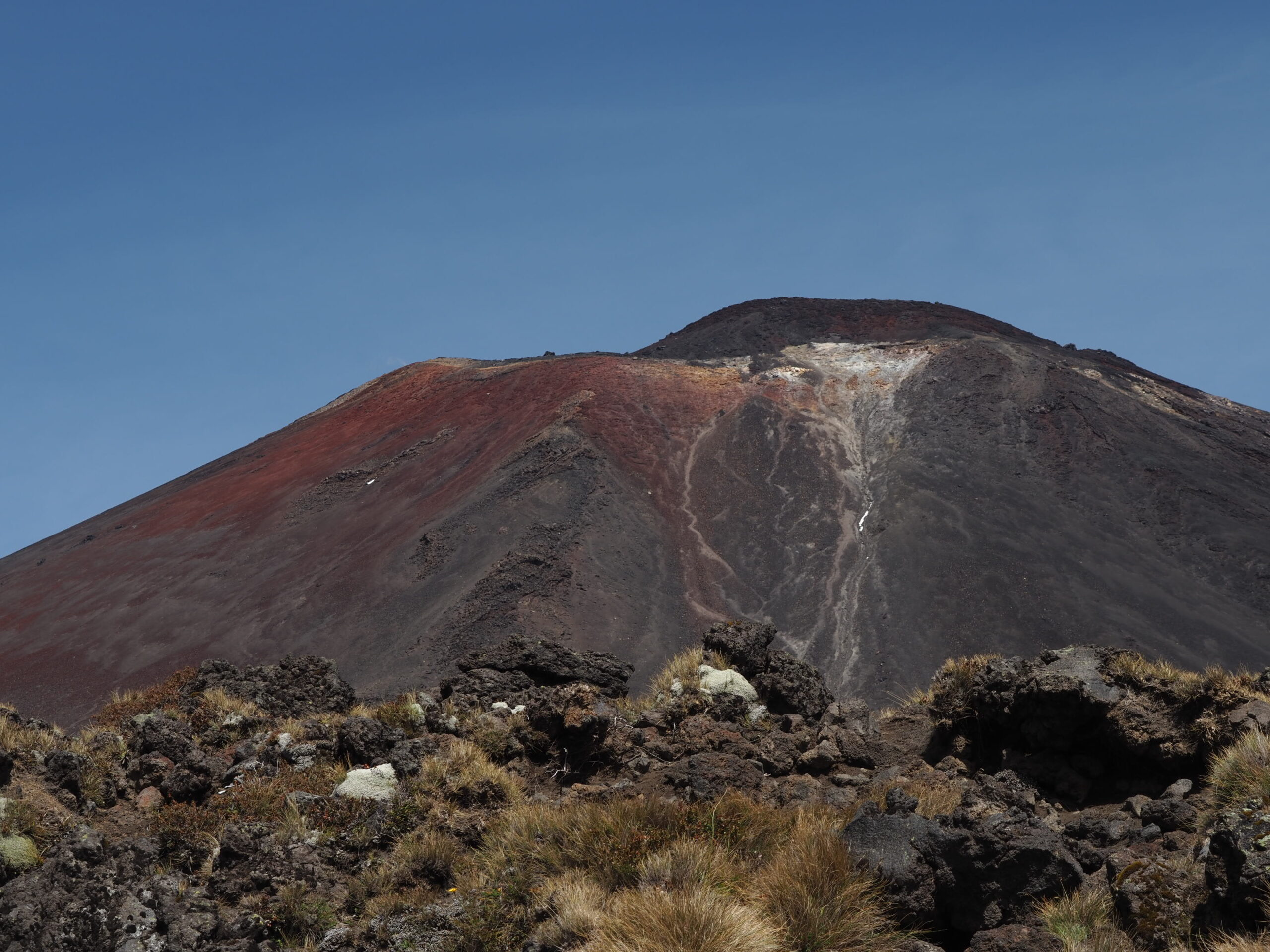
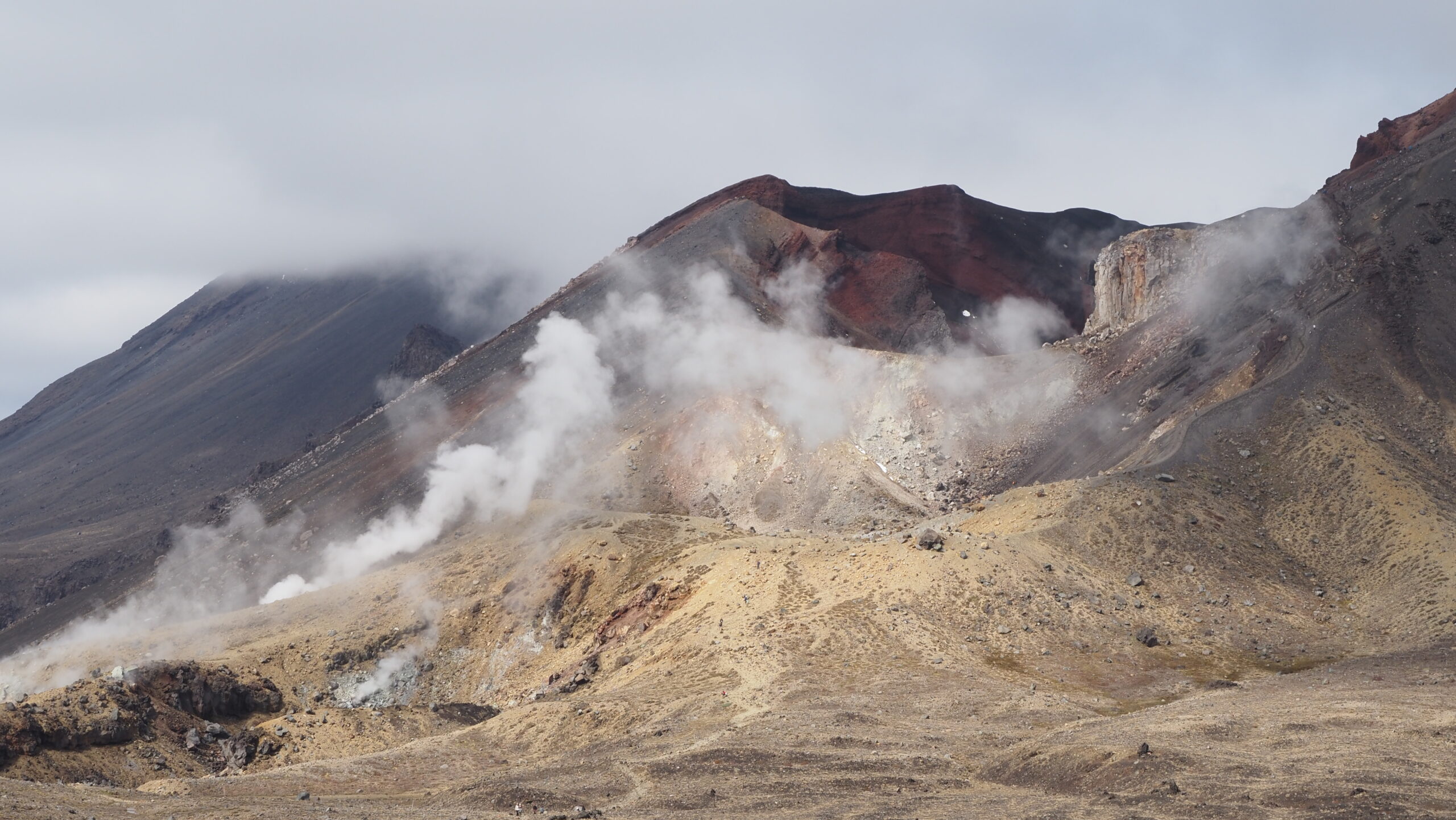
You’ll arrive at a first plateau, but the Red Crater (the highest point of the hike) is still far. For us, this is when we began to see blue skies; the mist gradually cleared, and it was quite mystical, adding a certain charm to the volcanic plateau, as if the still-smoldering lava was casting this opaque haze around us. Once you reach the heights of the plateau, you’ll catch a glimpse of Mount Ngauruhoe, recognizable by its conical shape, rising to 2,287 meters. In winter, it’s completely snow-covered, while in summer, it showcases a brown color with distinct touches of fiery red. It’s also New Zealand’s most active volcano. Out of respect, climbing it is prohibited since it is sacred to the Māori, but the view from the plateau is more than enough!
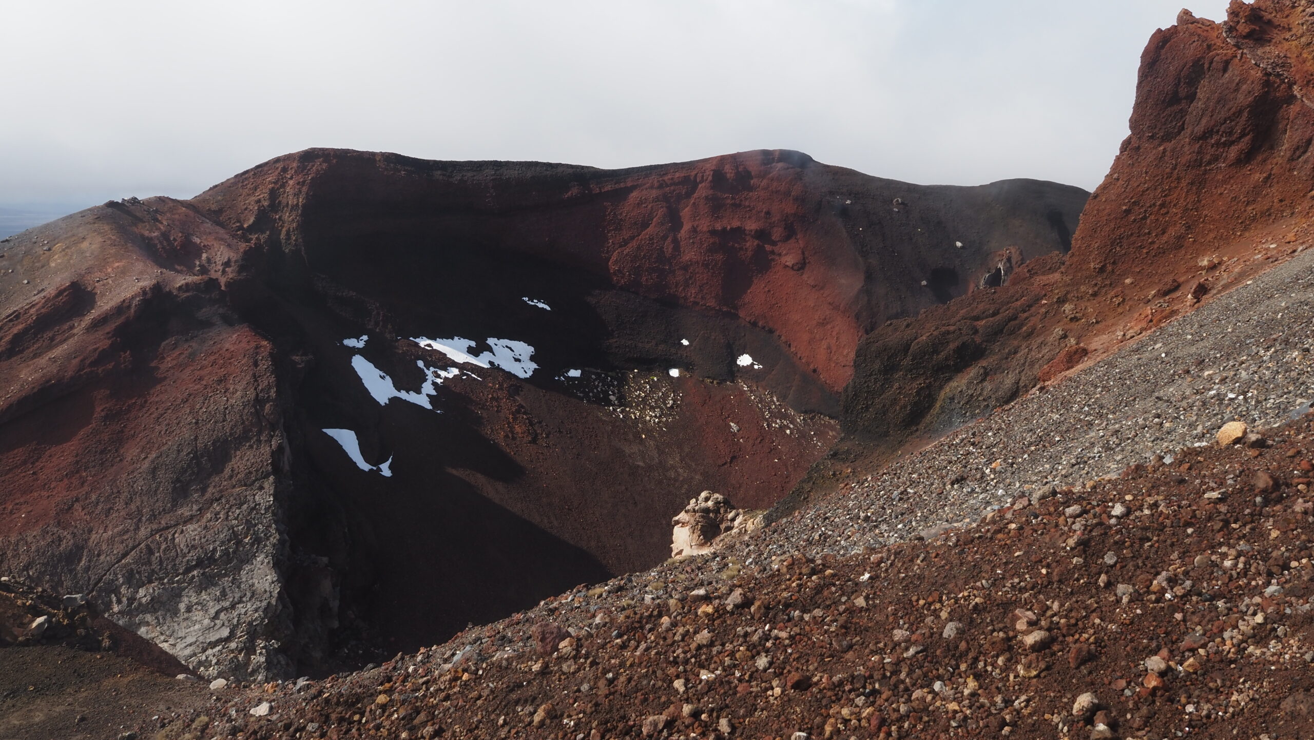
Your ascent will take you to the Red Crater at about 1,900 meters. Its striking color is characteristic of volcanic landscapes, and it’s quite impressive to venture a bit closer and see just how deep it is.
After 3 hours walking, you will then begin to go down. It is the trickiest part; although the path is marked, the slopes are slippery due to the dark volcanic sand. This part definitely works your thigh muscles and knees, so having a hiking pole can be very helpful!
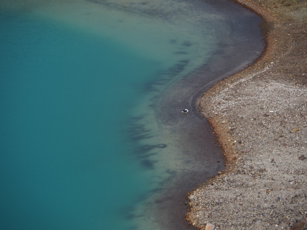
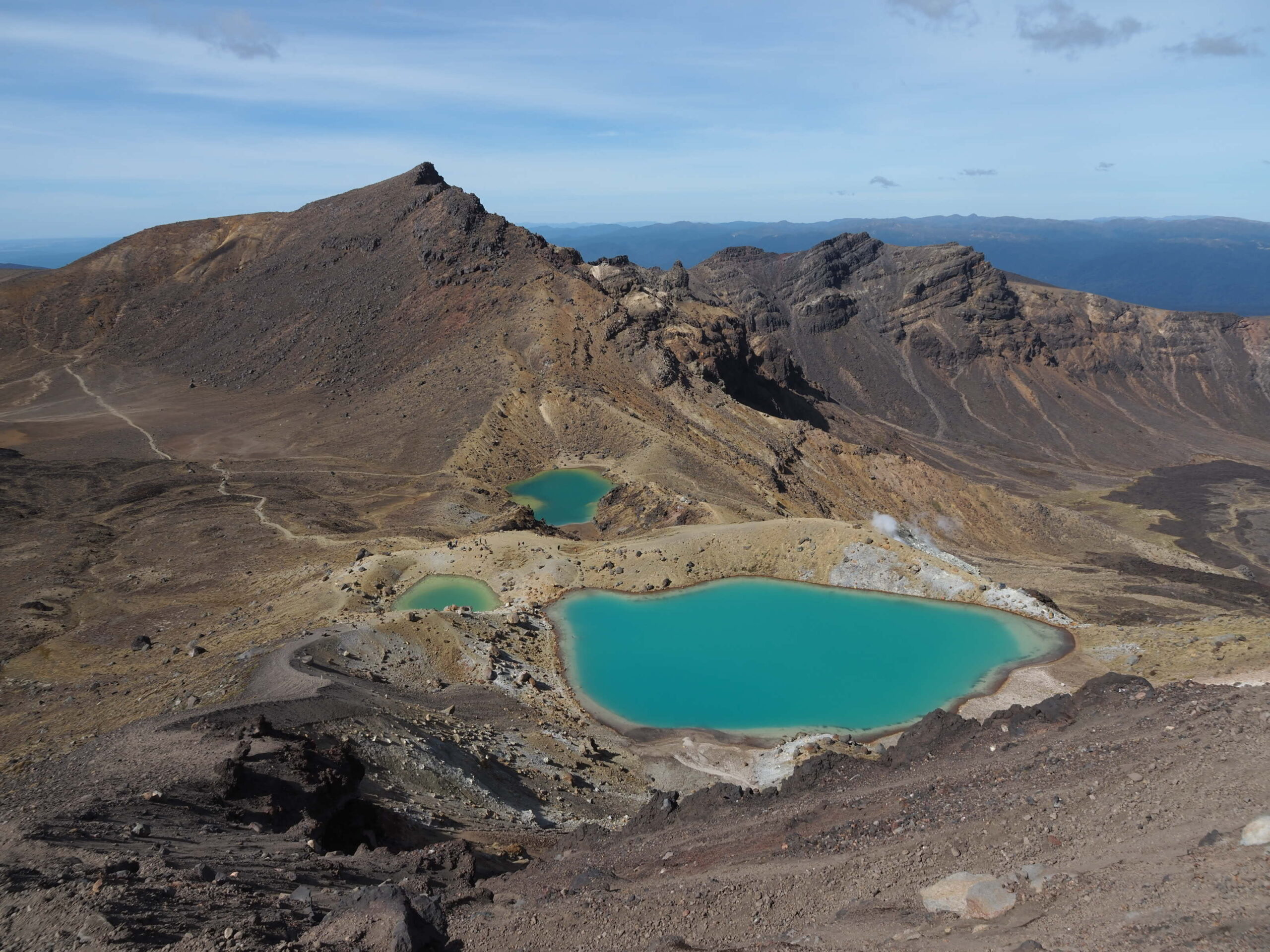
This descent leads to the two Emerald Lakes, and their names say it all. The Māori named the lake Ngā Rotopounamu (greenstone-hued lakes). It’s a sacred lake formed within craters, resulting from a mix of snow, ice, and minerals. When limestone reacts with the calcium naturally present in the water, and sunlight reflects off it, it creates this stunning green color. The water is also very cold and acidic, with thermal steam rising around the lake, giving off a rotten-egg smell (sulfur), so avoid touching it. Continue on, and you’ll encounter another immense lake: the Blue Lake (Te Wai Whakaata o Te Rangihīroa – Rangihīroa’s mirror). This lake is tapu (sacred) to the Māori, so you cannot touch it or eat and drink near it.
After passing the Blue Lake, the track winds around the northern slope of Tongariro, then descends along a long zigzag path towards the end of the trail. This section can be a bit boring for some because you’ve already seen the most beautiful sights, and the descent can feel quite long. However, you’ve done the hardest part ! You’re now over halfway through, with panoramic views of the valley surrounding Tongariro, as well as informational signs about the last eruption of Tongariro in November 2012, near the Ketetahi Hot Springs (currently closed). Finally, the last kilometers bring you to walk through a forest before reaching the parking area where your shuttle will be waiting to take you back.
Congratulations, you did it!